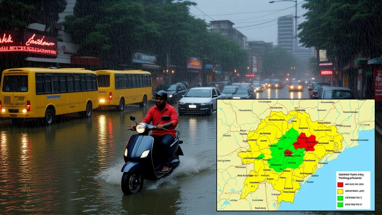
When India Meteorological Department released a red‑alert bulletin on October 2 2025, residents of Bihar braced for what could become a historic downpour. The agency warned that a fresh Western Disturbance moving in from the northwest, combined with moisture from the Arabian Sea and Bay of Bengal, might dump more than 21 cm of heavy rainfall across the state on October 3‑4. Temperatures were set to hover between 24 °C and 33 °C, while isolated thunderstorms could pepper the region through the first week of October.
Monsoon Context and Recent Rainfall
October typically marks the tail‑end of the Indian monsoon, but the last ten days have already hinted at an aggressive turn. On September 25 and 28, several districts in Bihar recorded sudden spikes of rain—up to 12 cm in Muzaffarpur—signalling the atmosphere’s readiness to unleash more water. The pattern mirrors the 2022 post‑monsoon surge that caused floods in the Ganga basin, a reminder that even “late‑season” rains can be perilous.
IMD’s October 2 Bulletin: What It Said
The bulletin, titled “East and Central India Weather Outlook (Oct 1‑7, 2025)”, laid out a layered forecast. For Bihar, it detailed:
- Light to moderate rain and thunderstorms over most districts on Oct 2‑7.
- Isolated very heavy rain, exceeding 21 cm, especially on Oct 3‑4.
- Potential hailstorm activity in the northwest fringe of the state on Oct 5‑7, peaking Oct 6.
According to the IMD, an upper‑air cyclonic circulation lingering over Arunachal Pradesh at the lower tropospheric level was the engine driving this moisture convergence. The agency’s spokesperson, Arun Kumar Singh, told reporters, “The confluence of westerly monsoonal flow and the western disturbance creates a perfect brew for intense convection. Communities should stay alert, especially in flood‑prone districts like Begusarai and Khagaria.”
What the Numbers Mean for Bihar’s Districts
Based on Weather25.com models, the average October rain for Bihar is roughly 97 mm spread over 3‑8 rainy days. This week’s forecast alone could exceed 50 mm in some pockets, pushing rivers like the Gandak closer to breach levels. In Patna, the state capital, Patna’s AccuWeather profile predicts a high of 28 °C (82 °F) and a low of 23 °C (74 °F) on Oct 4, with humidity nudging 85 %—conditions ripe for sudden squalls.
Local municipal officer Meena Devi confirmed that the city’s drainage system has been cleared, yet warned, “Even moderate rain can cause waterlogging in old neighborhoods because the sewage lines are aging.” She urged residents to keep sandbags handy.
Responses from Authorities and Residents
District collectors across Bihar have already issued separate alerts. In the flood‑vulnerable district of Bhagalpur, collector Rohit Sharma ordered schools to remain closed on Oct 4‑5 and mobilised two rescue teams equipped with inflatable boats.
Meanwhile, farmers in the Mithila region expressed mixed feelings. “We need rain for our paddy, but not this much,” said 45‑year‑old farmer Sanjay Jha. “If the water rises faster than the fields can absorb, we’ll lose the crop.”
Social media chatter on Twitter (now X) has been dominated by the hashtag #BiharRainAlert, with over 12,000 mentions within the first six hours of the IMD’s release. Many users shared live footage of sudden downpours turning streets into streams.

Broader Regional Outlook: Beyond Bihar
The same disturbance is expected to slam neighboring states. In Chhattisgarh, the IMD predicts rainfall up to 180 mm in the central districts, while Odisha could see coastal flooding from storm surges. Climate‑data.org notes that October 2025 is already ranking among the top ten wettest Octobers for eastern India over the past three decades.
Experts say the interaction between the western disturbance and the lingering monsoon trough is a textbook case of “enhanced baroclinic instability,” a fancy way of saying that the atmosphere is pulling in a lot of moisture from opposite directions, making storms more violent.
Safety Recommendations and What to Watch For
Authorities advise the following steps:
- Keep mobile phones charged and follow official updates from the IMD’s website or local radio.
- Avoid low‑lying areas and riverbanks after 6 pm, when rainfall intensity typically peaks.
- Secure outdoor items—chairs, planters, and tarps—that could become projectiles in strong gusts.
- Prepare an emergency kit with water, dry food, a flashlight, and basic medicines.
For commuters, the Bihar State Road Transport Corporation (BSRTC) has announced that bus services on routes crossing the Ganga will be suspended between 7 am and 9 pm on Oct 4‑5. Train timings on the Howrah‑Patna line are also under review.
Key Facts
- Date of alert: October 2 2025
- Primary threat: >21 cm of heavy rainfall in Bihar on Oct 3‑4
- Temperature range: 24 °C – 33 °C (75 °F – 91 °F)
- Areas most at risk: Begusarai, Khagaria, Patna, Bhagalpur
- Related regions affected: Chhattisgarh, Odisha, West Bengal
Frequently Asked Questions
How will the heavy rainfall affect farmers in Bihar?
The sudden deluge could flood paddy fields before the crop reaches maturity, potentially cutting yields by 15‑20 %. While some water‑logged areas may benefit later, most farmers are advised to drain excess water and protect seedlings with raised platforms.
What safety measures have local authorities put in place?
District collectors have activated emergency response teams, cleared drainage channels, and issued school closures in high‑risk zones. Relief camps are ready in Patna and Muzaffarpur, stocked with food, blankets, and medical kits.
Why is a Western Disturbance causing such intense rain?
A Western Disturbance draws cold, moist air from the Mediterranean and Atlantic, colliding with the warm, humid monsoon flow from the Bay of Bengal. This clash creates strong upward motion, leading to heavy condensation and, ultimately, intense rainfall and occasional hail.
Will the rain affect transportation in the region?
Yes. BSRTC bus services across flood‑prone corridors are temporarily halted, and several railway sections near the Ganges are under speed restrictions. Travelers are urged to check the latest schedules before planning trips.
How does this event compare to previous October storms?
The forecasted 21 cm of rain rivals the October 2022 event that caused historic flooding in the Ganga basin. However, because the IMD has issued a red alert this time, preparedness levels are expected to be higher, potentially reducing casualties.